HSIS highway safety information system
Research, Development, and Technology Turner-Fairbank Highway Research Center 6300 Georgetown Pike bull; McLean, VA 22101-2296
The Highway Safety Information System (HSIS) is a multi-State safety database that contains crash, roadway inventory, and traffic volume data for a select group of States. The participating States, California, Illinois, Maine, Michigan, Minnesota, North Carolina, Ohio, Utah, and Washington, were selected based on the quality of their data, the range of data available, and their ability to merge the data from the various files. The HSIS is used by FHWA staff, contractors, university researchers, and others to study current highway safety issues, direct research efforts, and evaluate the effectiveness of accident countermeasures.
Evaluation of Lane Reduction “Road Diet” Measures and Their Effects on Crashes and Injuries
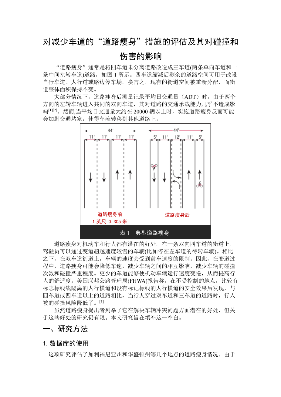
“ROAD DIETS” ARE OFTEN CONVERSIONS OF FOUR-LANE UNDIVIDED ROADS INTO THREE lanes (two through lanes and a center turn lane), as shown in figure 1. The fourth lane may be converted to bicycle lanes, sidewalks, and/or on-street parking. In other words, existing space is reallocated; the overall area remains the same.
Under most average daily traffic (ADT) conditions tested, road diets have minimal effects on vehicle capacity, because left-turning vehicles are moved into a common two-way left-turn lane.(1,2) However, for road diets with ADTs above approximately 20,000 vehicles, there is a greater likelihood that traffic congestion will increase to the point of diverting traffic to alternate routes.
Road diets can offer potential benefits to both vehicles and pedestrians. On a four-lane street, drivers change lanes to pass slower vehicles (such as vehicles stopped in the left lane waiting to make a left turn). In contrast, driversrsquo; speeds on two-lane streets are limited by the speed of the lead vehicle. Thus, road diets may reduce vehicle speeds and vehicle interactions during lane changes, which potentially could reduce the number and severity of vehicle-to-vehicle crashes. Pedestrians may benefit because they have fewer lanes of traffic to cross, and because motor vehicles are likely to be moving more slowly. The Federal Highway Administration (FHWA) report Safety Effects of Marked vs. Unmarked Crosswalks at Uncontrolled Locations found that pedestrian crash risk was reduced when pedestrians crossed two- and three-lane roads, compared to roads with four or more lanes.(3)
Although road diet advocates enumerate these potential crash-related benefits, there has been limited research concerning such benefits. This study was designed to help fill this gap.
Methodology
Databases Used
This study evaluated road diets at several locations in California and Washington. Because both States are part of FHWArsquo;s Highway Safety Information System (HSIS), researchers believed that the necessary high-quality crash data for a large number of crash, roadway, and vehicle variables would be available from computerized HSIS files. However, because all the road diets were found to be on non-State routes, the data were collected manually from local agency files.
Research Design
Researchers selected a treatment and comparison group, and obtained data for two time periods: one before and one after treatment installation. The road diets (i.e., treatment sites) were matched with four-lane streets that were otherwise similar (i.e., comparison sites). Researchers then obtained crash data for four groups: 1) Road diets—before period. 2) Road diets—after period. 3) Comparison sites—before period. 4) Comparison sites—after period.
Most comparison sites were four-lane undivided roads that were near the road diets (such as a parallel road one or two blocks away, or a perpendicular road). A few comparison sites were four-lane undivided sections of the same road beyond the location where the road diet was installed. The comparison sites were selected to be similar to the road diets in terms of roadway functional class, type of development (e.g., commercial or residential), speed limit, intersection spacing, and access control.
Site Selection
Local traffic engineers in California and Washington were contacted to determine where road diets were located. Road diets were identified in eight cities: Bellevue, WA, Mountain View, CA, Oakland, CA, Sacramento, CA, San Francisco, CA, San Leandro, CA, Seattle, WA, and Sunnyvale, CA. These are not the only cities in California and Washington that have road diets, but they are the locations that the local traffic engineers provided.
Researchers identified candidate comparison sites by reviewing maps and talking to local traffic engineers. The final list of sites contained 30 road diets and 50 total matching comparison sites in 8 cities. Because of missing crash data, only 12 road diets and 25 comparison sites are included in this analysis, as described below. The road diet sections ranged from 0.13–4.09 kilometers (km) (0.08–2.54 miles (mi)). The comparison sites sections ranged from 0.21–4.88 km (0.13–3.03 mi).
Data Collection
Local traffic engineers provided crash and ADT data for the road diets and comparison sites. At most locations, 1 or more years of data were obtained for each of the before and after periods. The actual time periods varied considerably from site to site, depending on how much data the city had available and when the road diet was installed. Because all four seasons were represented, seasonal variations in crashes were taken into account.
Analysis
As noted above, researchers initially obtained crash data for 30 road diets and 50 comparison sites. However, many locations had small sample sizes of crashes because of short segmen
剩余内容已隐藏,支付完成后下载完整资料
英语译文共 8 页,剩余内容已隐藏,支付完成后下载完整资料
资料编号:[239895],资料为PDF文档或Word文档,PDF文档可免费转换为Word

