英语原文共 10 页,剩余内容已隐藏,支付完成后下载完整资料
Programming Language Python for Data Processing用于数据处理的编程语言Python
Ing. Zdena Dobesova, Ph.D. Department of Geoinformatics, Faculty of Science Palackyacute; University in Olomouc Olomouc, Czech Republic zdena.dobesova@upol.cz
Abstract—Geographic information systems belong the group of applications that process spatial data. 摘要-地理信息系统是一种处理空间数据的应用程序。Some spatial analyses are operated repetitively in the same way for different area or district.某些空间分析以相同的方式对不同的区域或地区重复进行。Therefore it is useful when the data processing can be run automatically by program extension designed especially for batch data processing. 因此,当数据处理可以通过专为批量数据处理而设计的程序扩展自动运行时,这是非常有用的。ArcGIS software offers a possibility to design the steps of data processing by data flow diagram in the graphic editor ModelBuilder. arcGIS软件提供了在图形编辑器ModelBuilder中通过数据流程图设计数据处理步骤的可能性。In some cases the data flow diagram which is designed in ModelBuilder component is not sufficient for all require tasks. 在某些情况下,在ModelBuilder组件中设计的数据流程图不足以满足所有需要执行的任务。In such cases, it is possible to automatically convert data flow diagram into the Python language and supplement the program code with other program constructions and commands. 在这种情况下,可以自动将数据流程图转换为Python语言,并使用其他程序结构和命令来补充程序代码。Some practical examples are presented in this article. 本文提供了一些实际示例。All Python scripts were developed as a part of several research projects at Department of Geinformatics at Palackyacute; University in the Czech Republic. 所有Python脚本都是捷克共和国Palackyacute;大学Geinformatics系几个研究项目的一部分。This article is a sum of experience with scripting in Python for ArcGIS geoprocessor本文是使用Python for ArcGIS地理处理器编写脚本的经验总结
Keywords - ArcGIS; cartography; dataflow; geoprocessor; GIS; scripting. 关键字-ArcGIS;制图;数据流;地理处理器地理信息系统脚本。
- INTRODUCTION介绍
Geographic information systems (GIS) are specific information systems that are oriented to process spatial data. 地理信息系统(GIS)是面向处理空间数据的特定信息系统。Earth phenomena are represented by graphical data in a raster or vector format. 地球现象由栅格或矢量格式的图形数据表示。Vector data are often joined with a lexical data in a relation database. 向量数据通常与关系数据库中的词汇数据结合在一起。The vector format uses three main forms of representation when describing reality: points, lines and polygon.在描述现实时,矢量格式使用三种主要表示形式:点,线和多边形。
Nowadays, GIS are becoming more and more popular among municipal and territorial organizations, environmental experts for their ability to manage the spatial data [1]. 如今,由于GIS具有管理空间数据的能力,GIS在城市和地区组织(环境专家)中越来越受欢迎。Spatial decision making tasks, simulations of spatial evolution and tasks that involve comparing different data motivate growing interest in GIS. 空间决策任务,空间演化模拟以及涉及比较不同数据的任务激发了人们对GIS的兴趣。Common customers of GIS are usually familiar with interactive processing of data.GIS的普通客户通常熟悉数据的交互处理。
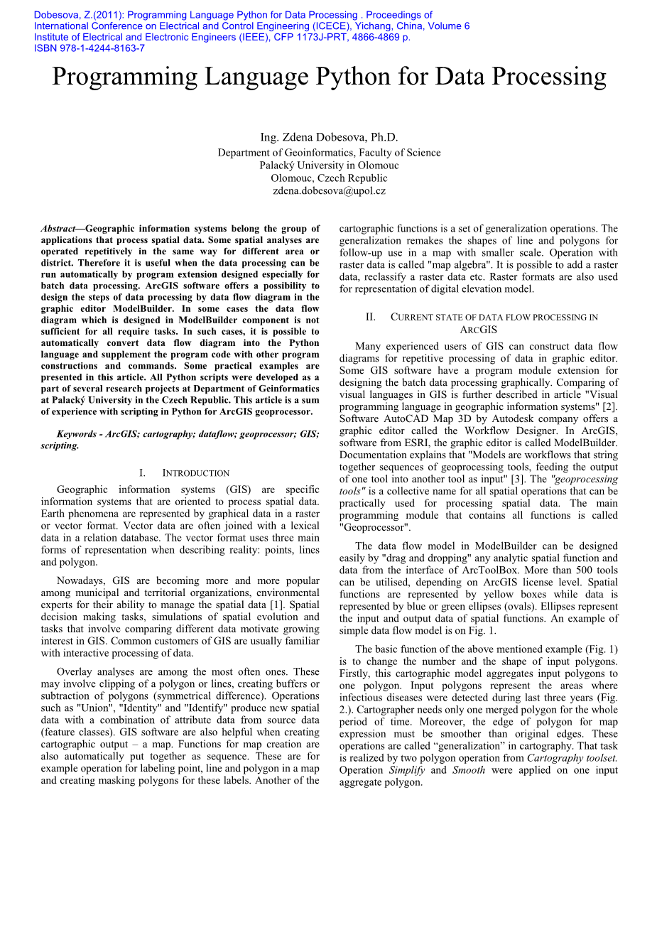
Overlay analyses are among the most often ones. 重叠分析是最常见的分析之一。These may involve clipping of a polygon or lines, creating buffers or subtraction of polygons (symmetrical difference). 这些可能涉及多边形或直线的剪裁、创建缓冲区或多边形的减法(对称差分)。Operations such as 'Union', 'Identity' and 'Identify' produce new spatial data with a combination of attribute data from source data (feature classes). 诸如“联合”(Union),“身份”(Identity)和“标识”(Identify)之类的操作会结合来自源数据(要素类)的属性数据生成新的空间数据。GIS software are also helpful when creating cartographic output – a map. 在创建地图输出(地图)时,地理信息系统软件也很有用。Functions for map creation are also automatically put together as sequence.

